Desert Online General Trading LLC
Dubai, United Arab Emirates
Desert Online General Trading LLC
Dubai, United Arab Emirates


🚀 Survey Smarter, Not Harder — Precision Meets Power in Every Field!
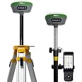
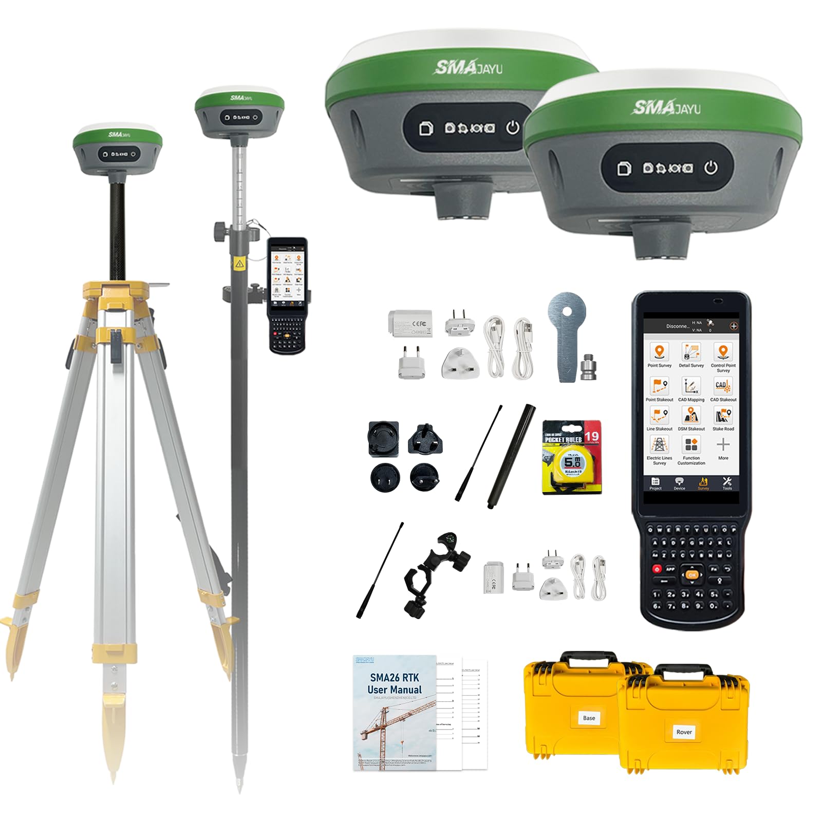
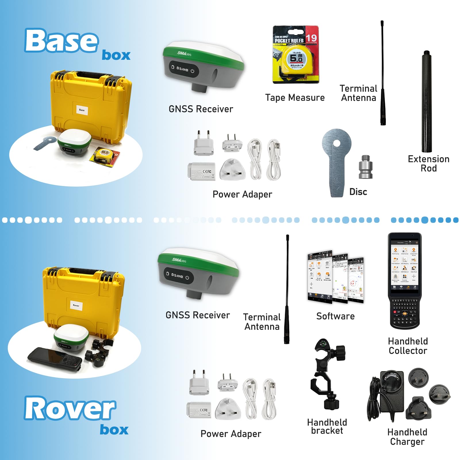
The SMA26 GNSS IMU RTK GPS Rover Base is a NOAA-certified, high-precision surveying tool designed for professionals demanding centimeter-level accuracy and extended operational range. Featuring a 10km UHF communication span, advanced 60° tilt compensation, and a powerful 10,000mAh battery, it supports flexible rover/base switching and broad protocol compatibility. With 32GB storage and multi-format file support, it’s engineered for seamless, efficient data collection across diverse geospatial applications.


| Item Weight | 19.84 pounds |
| Product Dimensions | 5.5 x 5.5 x 3.4 inches |
| Item model number | SMA26 |
| Batteries | 3 Lithium Ion batteries required. (included) |
| Display Size | 5 Inches |
| Battery Life | 2 days |
| Voice command | Buttons |
E**Z
Exceptional GPS equipment!
I'd like to start by saying though I've used and tested various brands of GPS equipment. I purchased this one and immediately was not disappointed. After about a month of tests, I've found this product to be reliable and consistently accurate.The GPS receivers will definitely run for more than a day with just one charge. The USB-C charging cables provided are great, especially compared to working with other major brands that require a special charging base for charging the batteries. As a test I went almost 5 miles away from my base and still had reception. The IMU is accurate as well.The data collector and software has been great as well. The software is pre-installed and runs pretty smooth. It allows you to plug in a SIM card for those that enjoy using NTRIP services for their surveys.Long story short, the unit and software is a great value for your money. Their customer service is amazing. Just send them an email and they will respond in under 24 hours with the correct and detailed information.I don't normally write reviews for anything, but this equipment is definitely worth purchasing and trying out, because you will not be disappointed.
D**.
Could not be more pleased
The learning curve on this was long, but it works like advertised. There are cons - no instruction manual; the data collector screen is difficult to see in bright sunlight; the available YouTube videos are not all that helpful - but the pros outweigh them. The units work well and provide real-time centimeter accuracy. The range is advertised as up to 1km, and I realize that is in the best of circumstances, but we are having no problem up to one mile in the hills and heavy foliage of the Ozarks. I suspect we can get even better range. The couple of times I have contacted the sellers, they have responded quickly. This is a good product at a fantastic price.
F**Z
/Discrepancias Significativas en Elevación y Dudas sobre la Fiabilidad del Equipo
I had to return this equipment due to a significant discrepancy in elevation measurements, showing a vertical difference of approximately 100 feet. Although the technical support team has been in contact with me, their response was that I need at least 3 known points to obtain an accurate elevation. However, if that’s the case, I don’t see the advantage of using GPS, as I could achieve the same result with a total station, which would also be lighter since I would be using a prism on the pole instead of a rover.I have reviewed comments from other users who report similar issues, while some mention that the equipment has worked perfectly for them horizontal and vertical. This leads me to believe that the unit I received might have some defect or configuration issue.He tenido que devolver este equipo debido a una discrepancia significativa en las mediciones de elevación, mostrando una diferencia vertical de aproximadamente 100 pies. Aunque el soporte técnico ha estado en contacto conmigo, su respuesta fue que necesito tener al menos 3 puntos conocidos para obtener una elevación exacta. Sin embargo, si ese es el caso, no veo la ventaja de utilizar un GPS, ya que podría lograr el mismo resultado con una estación total, que además sería más ligera, ya que en la vara no llevaría un rover, sino un prisma.He revisado comentarios de otros usuarios que reportan problemas similares, mientras que algunos mencionan que el equipo les ha funcionado perfectamente. Esto me hace pensar que la unidad que recibí podría tener algún defecto de fabricación o configuración.
P**I
Top notch submeter GPS unit
Top notch GPS unit. No more $5k yellow bricks that conck out and no more subscriptions. The software converts directly to DWG DXF SHP and many other formats and works great with autocad.
K**I
Worth the price.
I use this for simple land surveying for pipelines. Is as accurate as my system that was 10 times as much, maybe even a little better under trees. Will more than likely buy another in case something were to happen to this one. I can’t speak on longevity as I’ve only had it for about a year, but so far, so good.
D**.
Its a fight to get it to working
I spent hours trying to get this thing to work!! The manuals are of no help and all the Youtubes look like they are on highspeed play mode, you can't follow the steps. I finally did get the steps written down after stopping and rewinding numerous times. I went out and followed the steps and it still did not work. I happened to find the key (for me at least). You have to set up a project first. Then hit the "device" button and go to the communications screen and set it up with the correct serial number for the base unit and connect it (you may have to hit the right arrow for the S/N to show up on the screen). Then hit the "Base" button and set up the base unit by connecting to it and note the parameters (these will need to be the same for the rover). After these are set, hit "apply to base". Then go back to the "Communication" button and hit the "Stop" button (this is the step I could never figure out). You then need to hit the "right" button to display the list of S/N's again. You will find the rover S/N in the list. Pick it and connect it.Then go to the "Rover" button and make sure the communication parameters are the same as the base unit. As soon as you hit Okay, the units should indicate that they are in a fixed position!! I have been quite impressed with the accuracy that I have been able to get out of the system and I have been able to check in within hundredths on control established by others. I am still working on the "localization" side of things...will know more about how that performs here shortly.
ترست بايلوت
منذ أسبوع
منذ شهر